Boundary changes.
A further pressure on hedgerows comes from one-off houses in a rural setting, urban expansion, and development and re-zoning of land from agricultural to residential, industrial, or mixed use. This can often result in the removal of the existing hedgerow composed of a variety of species and its replacement by a hedgerow composed of a single, often non-native, species, a block built wall, or sometimes a dry stone wall. It is not an offence to destroy vegetation in the ordinary course of agriculture or forestry. Also it is not illegal to destroy vegetation while preparing or clearing a site for lawful building or construction works. Section 40 of the Wildlife Act, 1976, as amended by Section 46 of the 2000 Act,provides protection for hedgerows by providing that it shall be an offence for a person to cut, grub, burn or otherwise destroy hedgerows on uncultivated land during the nesting season from 1 March to 31 August, subject to certain exceptions. It is important that, where possible, necessary work to hedgerows is carried out outside this period. Unfortunately health and safety has been used as an excuse for cutting hedgerows outside this period. Where hedgerows have been removed by developers and others no record of the amount of hedgerows removed has been kept so we really have no way of knowing how much of the linear woodland of Ireland has been and continues to be lost. The mapping systems used do not record the type of boundary lines that did or indeed do exist in order for us to measure this loss. I have compared a small field section in my own locality to show the changes in boundaries using a chronological timeline. Below are the changes that I have recorded as of February 2012.
Gortaroe 1809-1816
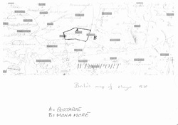
This map by William Bald was printed in 1830 and was actually surveyed between the years 1809-1816. The area highlighted is called Gortaroe and shows no field boundaries which correspond to todays boundaries.
Gortaroe 1896
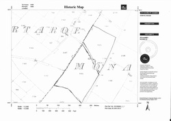
This map has been supplied to me by Ordinance Survey Ireland (OSI Map Shop Castlebar County Mayo). It shows Gortaroe, Monamore, in 1896. You will notice there is a marked difference to the field layout of 1830 as shown on the Bald map. There is no reservoir shown on either of these maps.
Gortaroe 1923.
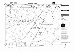
This map has been supplied to me by Ordinance Survey Ireland (OSI Map Shop Castlebar County Mayo). It shows Gortaroe, Monamore in 1923-24. The circular depression shows the reservoir and field boundaries not evident on earlier maps. The boundaries are not identified so I cannot know whether they are hedgerows or stone walls or any other type of boundary marker.
Gortaroe 2012.
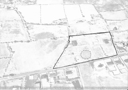
I obtained this map from Google Earth in February 2012. I have highlighted the area showing the field containing the reservoir. The reservoir has been filled in now and the area has been fenced off and allocated as allotment space by Mayo County Council. You can also see that development has taken place as the land was rezoned as rural residential and two houses have been built. The old reservoir area has been fenced off.
Gortaroe 2012. Map 1
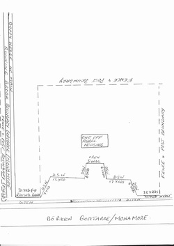
This is one of three maps that I have made showing the area on the 5th February 2012 and here we can plainly see the field boundaries as the exist today. The consist of a variety of boundary types. Hedgerows with a great number of gaps (gappy), dry stone walls, fence and post, open ditch, running brook, and mixed hedgerows with some maintenance by tractor-mounted flail cutting.
Gortaroe 2012. Map 2
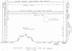
This is the second of three maps that I have made showing the area on the 5th February 2012 and here we can plainly see the field boundaries as the exist today. It is again plain to see the differences from earlier maps concerning the field boundaries. The types of boundaries are mixed, open ditch, dry stone walls, fence and post, Hedgerows that are mixed (hawthorn, bramble, gorse, wild cherry, ash, spindle) and raised banks. There is no evidence of hedgerow managenent and this can be seen in the huge amount of gaps, and the way the vegetation is beginning to represent a remnant rather than a hedgerow. The circular depression represents the filled in reservoir.
Gortaroe 2012. Map 3
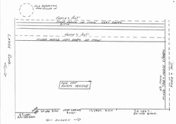
This is the third of three maps that I have made showing the area on the 5th February 2012 and here we can plainly see the field boundaries as the exist today. It is again plain to see the differences from earlier maps concerning the field boundaries. The types of boundaries are mixed, open ditch, dry stone walls, fence and post, Hedgerows that are mixed (hawthorn, bramble, gorse, wild cherry, ash, spindle) and raised banks. There
is no evidence of hedgerow managenent in places and this can be seen in the huge amount of gaps, and the way the vegetation is beginning to represent a remnant rather than a hedgerow. The circular depression represents the filled in reservoir. This map shows the area behind the reservoir/allotment area so I have put in the circular depression simply as a point of reference. There is some hedgerow maintenance on the Lodge road side of the site and this has been carried out by tractor-mounted flail cutter. As you can see from the map there are large areas that are either gappy or completly bare of hedgerow with no attempt to renovate the hedge. There has been development as you can see from the house that has been built but no planting has taken place.
is no evidence of hedgerow managenent in places and this can be seen in the huge amount of gaps, and the way the vegetation is beginning to represent a remnant rather than a hedgerow. The circular depression represents the filled in reservoir. This map shows the area behind the reservoir/allotment area so I have put in the circular depression simply as a point of reference. There is some hedgerow maintenance on the Lodge road side of the site and this has been carried out by tractor-mounted flail cutter. As you can see from the map there are large areas that are either gappy or completly bare of hedgerow with no attempt to renovate the hedge. There has been development as you can see from the house that has been built but no planting has taken place.
Field Boundaries.
A brief history of field boundaries:
The first permanent field boundaries were erected around the 12thcentury to mark townland boundaries. They subdivided various districts and usually followed rivers and other natural features (www.dardni.gov.uk). The field patterns you see today evolved slowly over time as townlands and farms were continually divided producing a pattern of irregular field boundaries (www.dardni.gov.uk). As the population increased after the early 1800s small villages known as ‘Clachans’ began to appear. These were run on a collective system and were seen as being inefficient by the English (and other) landowners. There began a reorganisation of the land which resulted in the grid-iron field pattern that we see today (www.dardni.gov.uk).
Other types of boundaries:
Earthen Banks.
These are wide grassy margins that may contain a variety of plants, scrubby trees, shrubs, and stones.
Ditches and Drains.
Once dug to drain waterlogged soils and to increase the amount of arable land. Today many ditches receive little or no
maintenance and as a result you may find species present that you would normally associate with a wetland habitat. Management should be carried out in the autumn/winter in order to minimise the impact on any wildlife present. Any vegetation that is removed should then be left on the margins of the ditch/drain so any amphibians or invertebrates may return to their habitat.
Dry Stone Walls.
These should be retained where present and if necessary repaired. They should be kept in keeping with local traditions and never painted. Dry stone walls support a variety of species such as mosses, lichens, ferns, frogs and mice. You may also find hedgehogs and newts hibernating within the thicker walls.
